
HOME

They say that one of the basic tenets of living sustainably is to know about the watershed in which you live. We're continually learning.
It's also good to ask, What is the land trying to do in this place? The Earth isn't static -- there is always something going on. Here are some of the things we know thus far.
Setting
This land is located near the north end of the Kitsap Peninsula, in the central Puget Lowland. Because the area is glacially carved, much of the topography is north-south trending.
Topography
Topography in this area is moderate, with elevations ranging from sea level to about 400 feet.
Elevations on our site range from 200 to 260 feet. The highest area is along the east boundary, where there is a bench that then slopes down to the wetland along the west boundary.
The elevation of the wetland slopes gently from the north boundary toward the south, reflecting the direction that our watershed flows.
At the southeast corner of the parcel is a salmonberry-filled wetland. It appears to be an isolated wet area. We haven't seen any standing water, and there is no indication of any flow direction.
At the center of the south boundary is a tree-covered knob. If you climbed the trees there, you could see Puget Sound.
Geology
The predominant geological type in this area, and therefore the parent material for most soils, is glacial till -- an unsorted, unstratefied, compact mixture of clay, silt, sand, gravel, and boulders deposited by the glaciers that came and went at least four times.
As the glaciers approached and receded from the area, meltwater streams deposited outwash sand and gravelly sand. The Indianola, Ragnar, Neilton, and Grove soils formed in the outwash material. (Source: Natural Resource Conservation Service 4.15 M)
According to a report done for us by Alkai Consultants, our homesite is at the intersection of two major types of till:
- Vashon Till
A mixture of clay, silt, sand, and rock (from gravel to boulder size) that is very stiff and impermeable.
- Frasier Glaciation deposits
Gravel, sand, diamict, or gray silt or clay containing clasts -- one type of rock, such as sandstone, formed from other types of rocks, such as igneous rocks -- brought by the glaciers from outside of the area.
Soils
Alkai states that the US Department of Agriculture has identified the following soil types on our site:
Poulsbo-Ragnar complex (0 to 30% slopes)
Poulsbo gravelly sandy loam (15 to 30% slopes)
Indianola-Kitsap complex (45 to 70% slopes)
Poulsbo-Ragnar soils formed in glacial till and glacial outwash. They break abruptly into drainageways, with little or no floodplain.
Poulsbo soils are nearly level to moderately steep, moderately deep, moderately well drained soils on broad uplands. They formed in glacial till. Typically, the surface of Poulsbo soils is covered by a mat of undecomposed needles, leaves, and wood fragments. The subsurface layer and subsoil are gravelly sandy loam. The substratum is a weakly-silicacemented hardpan about 4 inches thick over very compact gravelly sandy loam glacial till. Depth to the hardpan ranges from 20 to 40 inches.
Ragnar soils are nearly level to moderately steep, deep, well-drained soils on terraces and uplands. They formed in glacial outwash. Typically, Ragnar soils have a surface layer and subsoil of fine sandy loam. The substratum is loamy sand to a depth of 60 inches or more.
Indianola-Kitsap complex soils occur on dissected terraces of broad uplands and on side slopes of major valleys oriented mainly north to south. They formed in glacial outwash and glacial lake sediment. The Indianola soils occur on the upper slopes, and the Kitsap soils occur on the lower, steeper slopes.
The Indianola soil is deep and somewhat excessively drained. It formed in sandy glacial outwash. Typically, the surface layer is dark brown loamy sand about 7 inches thick. The subsoil is dark yellowish brown loamy sand about 22 inches thick. The substratum to a depth of more than 60 inches is olive brown sand. Permeability of the Indianola soil is rapid. The available water capacity is low. The effective rooting depth is 60 inches or more. Runoff is rapid, and the hazard of water erosion is severe.
The Kitsap soil is deep and moderately well drained. It formed in glacial lake sediment. Typically, the surface layer is very dark grayish brown silt loam about 5 inches thick. The upper part of the subsoil is dark yellowish brown silt loam about 8 inches thick. The lower part of the subsoil is mottled, light olive brown silty clay loam about 22 inches thick. The substratum to a depth of more than 60 inches is stratified, mottled, olive silt loam, silty clay loam, and silt. Permeability of the Kitsap soil is slow. The available water capacity is high. The effective rooting depth is 60 inches or more. Surface runoff is very rapid, and the hazard of water erosion is high. A perched water table is at a depth of 1.5 to 2.5 feet during the rainy season in winter and spring. This soil is subject to hillside slippage. Springs and seeps are common.
The slopes on our site appear to have been stable. However, the soils are moderately to highly erodible if they are disturbed or if there is channelized water flow. They recommended that any runoff from hard surfaces should be intercepted, collected, and piped to an appropriate drainage area.
Water
Much of the land in this area is very permeable, so there are relatively few surface streams. Rainfall tends to percolate right into the gorund.
Along the west side of the parcel, at the bottom of the slope, is a wetland. It is classified as a "depressional wetland," which appears to be the result of the clay layer at the bottom of the hill.
A very small perennial stream -- which we've named Fern Creek -- flows from the north and then curves out to the southwest. It then flows into the headwaters of Indianola Creek, one of two major streams in the area of our community. In the two years that we've watched Fern Creek, its flow seems to be pretty consistent throughout the year -- always a nice little trickle -- whether we're in a winter downpour or our summertime dry period. This indicates that it's a good wetland, acting just like a sponge that soaks up the water and slowly releases it.
Well logs from nearby wells indicate that groundwater in this area is generally at a depth of 200 to 300 feet. Our well is 253 feet deep.
Vegetation
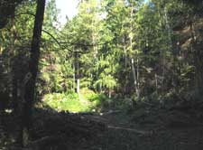
The land is forested with Douglas-fir, western hemlock, western red-cedar, big-leaf maple, and red alder. Several large Douglas-fir stumps indicate that it was logged sometime in the past. It seems noteworthy that we have seen no willows, even in the wetlands.
Major understory species include salal, salmonberry, elderberry, sword fern, bedstraw, springbeauty, and nettle. There is some huckleberry (Vaccinium spp.).
We've noted several invasive non-native plant species, which we'll be working to control. They include:
English ivy
Blackberry
Holly
There are other invasive non-native plants in the area, and we'll be watching for them. The most serious is Japanese knotweed, which appeared in streambottoms and other wet spots in our area in the last few years.
Wildlife
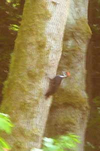
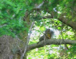
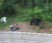
We're only beginning to get to know the wildlife that inhabits this area. Species that we know are here -- because either we've seen them, we've heard them, or we've seen their tracks or sign -- include:
|
(This native forest species is shy, and you usually only see it in pairs -- far different from the rock dove, or common pegeon that most people know!) (We still like the old common names for species such as the towhee, even though ornithologists have given them new names) Western tanager - we've seen a male and a female American Goldfinch - pair |
|
|
Red-legged frog | |
|
|
Pocket gopher (probably the northern pocket gopher Thomomys talpoides) | |
Shrew (unknown species) | |
Bat (unknown species) | |
Douglas red squirrel
Chipmunk Black-tailed deer Coyote
Black bear We expect there are also bobcats and cougars | |
|
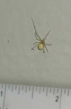
Mosquitoes (!) Jumping spider Crab spider More info about spiders in this area... |
We look forward to learning more about the creatures -- large and small -- with whom we share this land!
Resources
Washington Native Plant Society
Washington Department of Fish & Wildlife: Backyard Wildlife Sanctuaries